 An awesome idea proposed here.
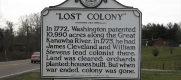
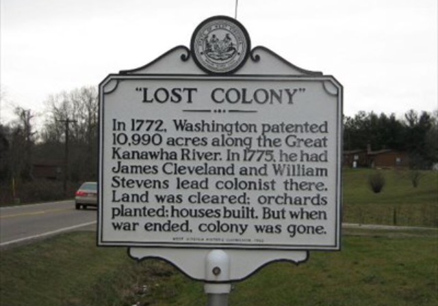
WV Tourism should jump all over this. Here is one of hundreds of West Virginia Historical signs. We pass them all the time. We barely read the header before we are down the road and out of memory. Sometimes briefly we think, it might have been interesting if we could have finished it. Sometimes because we pass some all the time we’ve actually stopped to read it. But that is rare and far between.
Wouldn’t it have been nice if we could have read it. And if it really picked our interest actually got MORE information at our leisure?
What if these historical markers could speak to us as we drive. Here’s the concept. You download the WV Historical Marker app on your phone or tablet and as you are driving and you pass a marker you get an alert and a small download on your phone. At your next stop you can see a photo of the marker you passed. Clicking on it opens a small PDF file giving you a one-page “the rest of the story” with photos of the person or place that even has a “for more information” link at the bottom that connects you to sources like: the WV Historical Society, WV Tourism, County CVB or whatever applies to the subject displayed on the plaque. History teachers everywhere would be happy.
Problem is, presently the app doesn’t exist. But it could.
The Project All Spelled Out
This doesn’t require as much work as you think. Plaques are already up (even if they are ignored), web sites exist. Basically you need to create three items:
THE WV HISTORICAL APP
An app that can be downloaded that “listens” for signs (either because they trigger a download from tourism when they pass a certain gps) or because there are active markers mounted on the back of the signs. Any good programmer (even a game maker) could create this.
HISTORICAL SIGN MARKERS
This might take a little more ingenuity. Small electronic devices like electronic watches with a small long life battery could actually send out passive signal that could be picked up by apps passing through the field. The device could ‘send’ a small file (or just a signal) that it is a marker (and gps info for that location would actually send a file from the tourism site). Or maybe this could be moot with the app itself launching ‘sign’ info on the app as gps is crossed by the app itself (creating the sense it ‘picked’ up a marker, when actually the gps told the app it was close to a known marker)
WV HISTORICAL MARKER DATA AND FILE BUILDING
Data might be left to the WV Historical people who put up the signs in the first place, just for accuracy. And you can be sure there is MORE they wanted to tell but didn’t have room on the sign (and probably have pictures too). A data base of PDF files would need to be built that would be accessed by the tourism app and downloaded to individual devices as they pass a trigger gps sign. It would take a little extra work to add appropriate extra links. I mean if this is a County marker, it could be linked to helpful county sources for tourism, history or more. Individuals (such as Solomon Osborne in Clay County) could be linked to even private historical sites that keep his biography. Links would have to be added discriminately by their appropriateness at the bottom of the info PDF sent out by tourism.
Why this is an awesome idea:
These markers were set originally that West Virginians would know and be proud of their history. I have children and grandchildren who have lived close to some if these markers and have never read them as they rushed past them in their daily lives.
If this app were created and promoted by the tourism and culture and history divisions, West Virginia history teachers everywhere would rejoice. More, for once, other states would be envious of West Virginia who has grasped just how important our history is and is proactive about it. I can even imagine history teachers in other states telling their students that “if you take a trip through West Virginia on your way somewhere this spring break, I want you to download the free WV Historical Marker app and when you get back I want you to share what you discovered with the class!” I mean, wouldn’t it be awesome if some class out in Wisconsin were discussing the “Mullins Yellow Delicious Apple first discovered in Clay County, West Virginia.”
Sounds like a worthwhile project for talented people. I’m talking to you Aaron and Lorna Frye, Cassy Holcomb, Emily Mottsheard, Jason Stuber, among others. Hey, Jerry Stover, wouldn’t this be an awesome history project for a high school or college class?